

Για τα ZWCAD PRO, AutoCAD, GstarCAD, BricsCAD,
και συμβατό με Windows 11


In v9 you will find the powerful enhanced Multi Background Maps, the practical Rubber Sheet edition, Multi Labels, User-defined Coordinate Systems, and many more news and enhancements that will allow you to address tasks related to spatial and territorial design and analysis like never before.
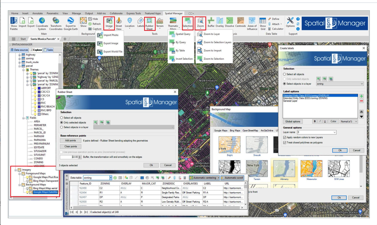
- Rubber Sheet
- Elastic Deformation of geometries based on 2 or more Control points
- Specify ‘Base’ and ‘Reference’ points that define the Deformation to be processed
- The more points you enter, the more accurate the results will be
- The order in which you select the points and the spread of the points will affect the results
- Apply defined Deformation to the objects you select, using any selection method
- Multiple Background / Foreground Maps
- Show simultaneously several Image Maps in your drawing
- Add Maps including transparent areas to be overlaid with others Maps, transparent or not
- Manage the Maps in the of the main palette Explorer section, as can be done with Thematics
- Activate or deactivate Image Maps, remove them, manage their overlapping positions, etc.
- Add any kinds of Image Maps, either application-preset Maps as User-defined Maps
- Choose whether you need only one Background Map or multiple Image Maps
- Improved Background Maps
- New ‘Stadia Maps’ preset group (Some previous ‘OpenStreetMap’ maps and some new ones)
- New Maps into the ‘OpenStreetMap’ group
- Removed the size limitation of the Background Maps window (display more Groups and/or Maps)
- WMTS Background Maps detection has been improved
- Raster images and Photos
- Specific command for Importing Raster images or Photos, now also including GPS location (EXIF)
- Export located Raster images in drawing and/or Geo-reference and Coordinate Systems files
- Multi-Labels
- Label objects with multiple texts (MText) including multiple lines of data
- Include Object Data fields, CAD properties, Geometric values, etc.
- Add, remove or sort any field or property
- Define a global format for the Label and/or particular values (Color, Size, etc.) for each line
- Exporting to Google Earth
- The pin of the location point for exported Texts does not appear now, only the Labels
- It is now possible to keep the original Texts color for the resulting exported Labels
- Object Field Names are shown in bold characters when displaying data in Google Earth
- Import / Export
- It is now possible to export the Object Type in the Export processes
- Parameters of the last Import process can be now re-used
- Objects in Shapefiles that include Z coordinates will be imported by default as 3D Polylines
- Images coordinate system recognition from associated PRJ files when importing
- Selection and Zoom
- Invert objects Selection
- Zoom to Layer. Zoom to the objects on the selected Layers (by default on the current Layer)
- Zoom to Selection Layers. Zoom to the objects on the Layers of selected objects
- Zoom to Import. Zoom to the objects resulting from the last Import process
- Coordinate Systems
- Define and edit customized Coordinate Systems
- The new user-defined CRSs will be added to the list of thousands preset CRSs
- EPSG tables (CRSs and other objects) updated to version 10.096 (2023-09-30)
- Data providers
- New data provider for Cloud Optimized GeoTIFF / COG TIFF sources
- Shapefile MultiPatch files supported
- New enhanced data provider for GeoJSON files
- GeoJSON and ASCII files Encoding can be selected when importing
- Object Type is added as a data Field when importing GML files
- Support for OpenStreetMap OsmChange files (.OSC)
- Write capability (Export, etc.) for the LiDAR Data Provider (.LAS, .LAZ)
- AutoCAD 2024, BricsCAD 24, ZWCAD 2024, GstarCAD 2024 compatible
- … and more
Links για DOWNLOAD
Thematic Maps
Visualization in different Colors according to the values of the Data Fields
Different types of thematic (categorized, graduated, etc.)
Auto-generation of values or ranges. Add, delete or edit values or ranges
Dynamic color ramps (palettes, gradients, etc.)
Temporary or permanent visualization
Dynamic update when changing the values of the theme field
Option to add Hatches for closed objects
Support for several simultaneous themes
Thematic management in the new application Explorer
Direct Geo-coding
Insertion in a drawing or map of lists of postal addresses as Points
Selection and field sorting when composing addresses to be searched for
Multiple geo-coding servers (Bing, Google, OpenStreetMap)
Export of geo-coded results in CSV format
Reverse Geo-coding
Collection of Postal Addresses of objects in the drawing or map
Automatic geo-coding calculation for non-point objects (centroids, etc.)
Multiple geo-coding servers (Bing, Google, OpenStreetMap)
Creation of postal address tables in the drawing or map
Export of geo-coded results in CSV format
Fields value Calculator
Powerful tool for operations between values in Data Fields
Mathematical, date, logical, geometric, etc. operators and functions
Single or chained operations
Results on new or existing fields on any table of the drawing or map
Results preview
New 'Spatial Manager' Explorer
Management of Thematics, contextual access to functions, etc.
AutoCAD Map Object Data Reading
Conversion of AutoCAD Map Object Data Tables to SPM Tables
Supports conversion of multiple tables in one go
Optional deletion of AutoCAD Map tables when converting
Possibility to Attach several data Tables to any object
More 3D object types when Exporting to Google Earth KML/KMZ
3D Faces, 3D Solids, Meshes, etc.
New 'ESRI Geodatabase File' (GDB) data provider
Other news:
Google geolocation is added to the Search for Locations function
New global configuration of geographic service provider Keys, applicable in Background Map servers, Geo-coding services, etc.
Added write capability to the GeoJSON file data provider
New functions added for the application's Lisp API: Set the value of a data Field, Get the value of a data Field and Attach a data Table to an Object
Improved compatibility with PostGIS servers v10 and higher
Improvements in the Licensing system. In addition to other advantages, the following are included: License activation/deactivation via QR code, simplified the activation process for Updates/Support Extension Licenses and a Network License seat is now not reserved until the application is used
The necessary parameters are added to be able to define a network domain when configuring a Proxy server. It is also possible to use Windows authentication when configuring a Proxy server
Ordnance Survey Background Maps updated
New custom Coordinate System transformations have been defined and EPSG tables (CRSs and other objects) have been updated to the latest available version
AutoCAD 2023, BricsCAD 22, ZWCAD 2023, GstarCAD 2022 and Windows 11 compatible

Τι νέο είχε η έκδοση 7.1 για το ZWCAD 2023 PRO
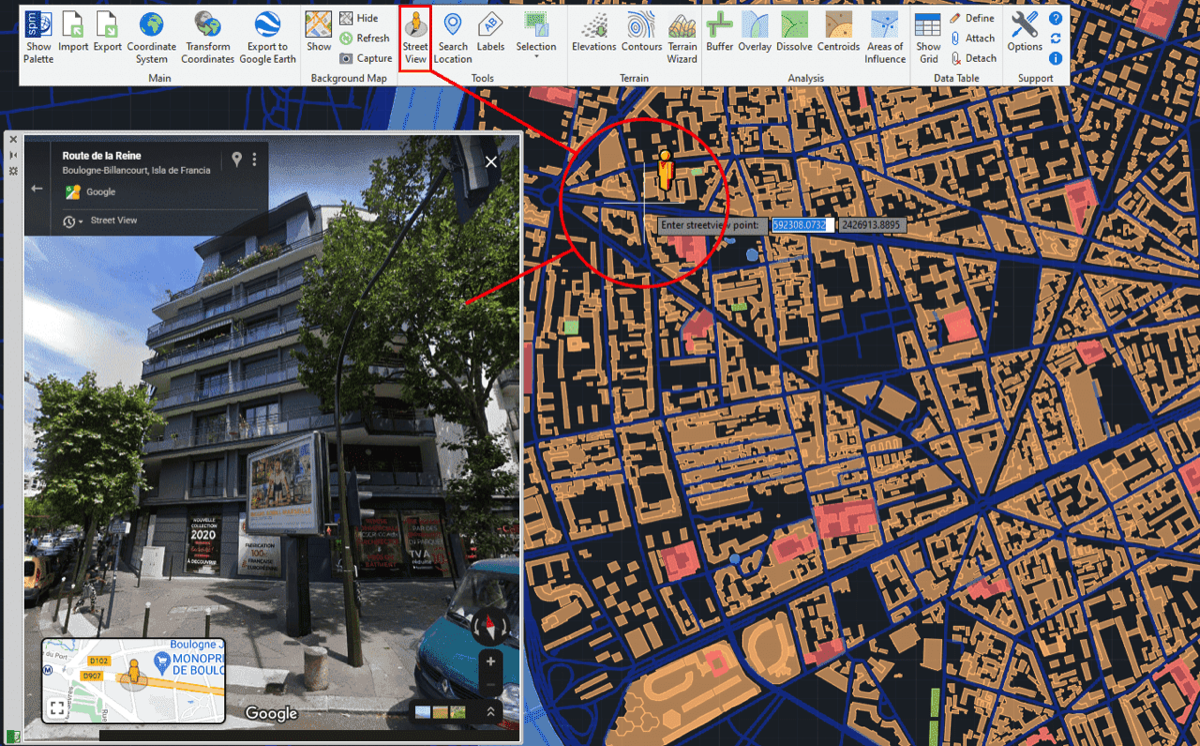
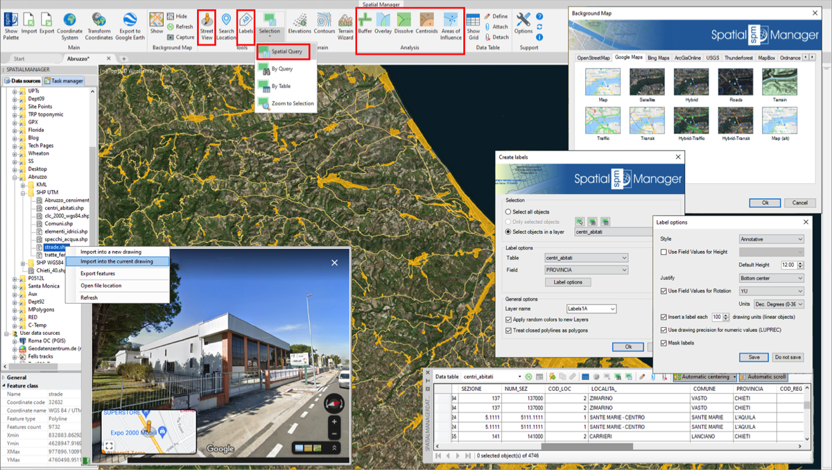
✓Street View - New palette for displaying (and navigate) dynamic Google Street View images on any drawing/map
✓GIS analysis tools - Advanced geometric and data operations for creating new objects from analysis processes. Buffer, Overlay (Intersect, Union, Erase, Identity, Clip, Paste or Symmetric Difference), Dissolve, Centroids and Areas of Influence
✓Spatial Query Selection - Advanced object selection system based on geometric and data operations between existing object groups (Intersect, Touches, Within, Contains, Disjoint, Overlaps or Crosses)
✓Object Labeling - Texts based on objects data
The recently released version 7.1 of ‘Spatial Manager’ is the first one compatible with ZWCAD 2023. This update adds this compatibility and some minor improvements and fixes to the version 7, one of the biggest technical developments in the application's history. From the Street View palette to many advanced analysis and selection tools, the user will find functionalities never seen in ZWCAD so far
Import/export spatial or GIS data into/from ZWCAD (2017 to 2023), and experience the advanced tools to manage spatial data, such as dynamic Background Maps, transform the drawing Coordinate System, quick drawing publishing in Google Earth, data structures and data grid, data and spatial queries, layer thematics, automatic and user labeling, Terrains, Search for locations, Street View navigation, GIS Analysis, etc.
Overview
In a nutshell
Import into ZWCAD from Google Earth (KML or KMZ), OpenStreetMap (OSM or PBF), Shapefiles (SHP), GPS, Points (many formats), Excel, Access, ESRI ArcInfo®, MapInfo, GML (GML or GZ), PostGIS, SQL Server, SQLite, and many more geospatial sources
Export from ZWCAD to Google Earth (KML or KMZ), Shapefiles (SHP), Points (many formats), MapInfo, PostGIS, SQL Server, SQLite, and many more geospatial targets
Transformation of coordinates optional
Backgrounds Maps, powerful and easy to use
Search Locations
Terrain functions including 3D points from elevation services, DTM meshes, contours, etc.
Publishing to Google Earth
Alphanumeric data tables as ZWCAD Extended Entity Data (EED/XDATA). Manage data tables and fields. Data viewer and editor included
Save Tasks to replay the import processes so many times as desired
Interface simple, intuitive and productive
Perpetual licenses. Pay once, no periodic fees
Spatial Manager™ for ZWCAD is a powerful ZWCAD plug-in designed for ZWCAD users who need to import, export and manage spatial data in a simple, fast and inexpensive way, which includes many possibilities not seen so far in ZWCAD.
It comes in a lightweight application that runs inside ZWCAD and allows the user to import and export geospatial data between ZWCAD drawings and geospatial files, data servers or data stores, display background maps and manage alphanumeric data and data tables.
Spatial Manager™ for ZWCAD imports spatial data, into new or existing ZWCAD drawings, as ZWCAD entities and Extended Entity Data (EED), using a powerful wizard which lets the user choose or select all the necessary import parameters in order to get differentiated spatial information in a CAD drawing.
Batch-import, automatic layering, fill of polygons, blocks according data values and mapped attributes, labeling, elevation, thickness or the spatial filter are only part of the application functionality when importing from spatial files, data servers, data stores, etc.
There are some advanced and powerful techniques to speed up the import processes, such as Import-all sources from a folder, database schema or multi-table file and others.
The "Tasks" save all the import processes parameters and options in order to repeat these processes so many times as desired. It is possible to execute one or more "Tasks" at once.
Spatial Manager™ for ZWCAD exports entities from the drawing to spatial files or databases, and saves their Extended Entity Data (EED) as alphanumeric data tables using a wizard, which shares some of the steps with the import wizard. In the same way, the user can choose or select the export parameters to define all the target data among a great number of possibilities.
There are options to export the Coordinates, Length or Area, the entities Layer, Handle and Elevation, the Attributes and the name of the Block references and their properties, the Texts and their properties, the Hatches and their properties, etc. The entities will be automatically filtered when exporting, and all the geometric operations needed to fit the target data format (such as segmenting curved entities) are automatically performed.
Spatial Manager™ for ZWCAD will calculate geometric transformations of the features in line with the import and export processes, which will depend on the chosen Coordinate System (CRS) for the source and target data.
The user can choose the appropriate CRSs from a complete CRS catalog or from a list which includes the most recent used CRSs.
Related wiki information...
Spatial Manager™ for ZWCAD will also automatically creates a new drawing including geometrically regenerated objects from the current drawing according to the transformation between two CRSs
Spatial Manager™ for ZWCAD allows to the ZWCAD users (from v.13), choose from among many Backgrounds Maps from many providers such as OpenStreetMap, Bing, MapBox, Ordnance Survey, etc. These maps will enhance the drawings quality and will let the users compare and check better.
The map images are automatically updated when the drawing view changes (zoom, pan, etc.) and the images resolution is automatically adapted to the view size. The user can define its own BG Maps in order to access WMTS/WMS/TMS map servers, import/export them and take static Snapshots of the Maps.
Related wiki information...
Spatial Manager™ for ZWCAD include functions to geo-locate in your drawing postal addresses, streets, neighborhoods or other geographical objects.
It allows you to access a text search window of locations and automatically zoom in or insert the geometry of the selected location or rectangular envelope.
Related wiki information...
Spatial Manager™ for ZWCAD allows you to create and manage Terrains and related entities.
3D Points / Blocks selected in drawing or built from Elevation service providers in any selected area.
2D or 3D Contours. Minor and major Contours. Contour labels. Layer separation and different color models. Contours attached to Data Tables including elevation values and type.
3D Terrain models, using 3D Meshes or other CAD/BIM entities. Automatic image projection and fitting of any Background Map (preset or user-configured) on one or more Terrains in their actual location.
Related wiki information...
Spatial Manager™ for ZWCAD includes a specific command designed to Export all or part of the entities in the visible Layers of the drawing and their data, to a KML or KMZ file (Google Earth) through a one-click operation.
The current Layers organization and the properties of the Layers and entities are considered when creating the resulting GE file, and this file can be opened in Google Earth (if installed).
Related wiki information...
Spatial Manager™ for ZWCAD will manage the alphanumeric data which may come linked to the entities in the import processes themselves but the users can also design and edit the structure which will be used to store the data. They can manage the tables and the fields according to their needs.
In addition, the data values can be modified in the palette of the application or through the powerful interactive Data grid, and there are two commands to select entities by Queries or according to the table that they are attached. As a plus, the application also provides a command that allows Zooming to the selected entities.
Related wiki information...
Spatial Manager™ for ZWCAD incorporates the UDS technology to easily connect with spatial database servers, or data stores, and also as the way the user can define the path to a particular spatial data file, including their own connection parameters.
UDSs avoid having to enter a lot of connection parameters, which are not easy to remember, and they are stored inside the user settings to take advantage of them in every application session.
Related wiki information...